The Torpel Way pictures, 23 March 2023.
Pictures by Simon Bradford; background information taken from the Torpel Manor Research project site.


The Torpel Manor Archaeological Research Project was an exploration of an enigmatic medieval fortification in Helpston in Cambridgeshire, the home of John Clare.
The project was a collaborative venture between the Langdyke Countryside Trust, the Helpston Archaeology Group, and the Department of Archaeology, University of York (supported by the Heritage Lottery Fund).
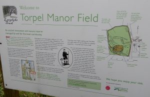
Torpel Manor Field is home to an important and visually impressive series of medieval and later earthworks, preserved by English heritage as a Scheduled Ancient monument. As such, the site is well-known locally, but little archaeological work has been undertaken, and its character, context and development are poorly understood. The aim of the project was to address this issue, and through a combination of non-invasive survey and archival work, characterise the social and physical landscape of the site, which lies in an area of considerable archaeological interest.
The field is reputedly the site of a ringwork castle or fortified manor, and is surrounded by earthworks that are indicative of further settlement and activity, probably in the post-conquest medieval period. There is an adjacent deerpark, and standing remains of what may well be an associated hunting lodge. Barnack features a medieval limestone quarry and seems to have been a major production centre for funerary monuments, and it is believed there is also a church with possible Saxo-Norman fabric in Helpston. The site’s apparent lack of later development makes it a good candidate for investigation, and there is potential to consider activity throughout the medieval period, as well as before it.
More generally, the close study of a Midland fortified site in its landscape context is considered an extremely exciting opportunity. The site lies close to other villages of early foundation and significance, such as (i.a.) Stamford, Barnack, Maxey, and Peterborough. The site has the potential to illuminate wider considerations of settlement, trade, and elite power in the medieval period. Its situation on the edges of the ‘midland’ and ‘ancient’ zones of medieval agriculture makes it a particularly interesting site through which to examine the development of the landscape and field systems, and their relationship to the adjacent villages and castle/manor. Work undertaken to date has included earthwork, magnetometry, and resistivity survey, and together with all the work done by the local community, with work being undertaken to bring the project together for publication. It is clear that the site preserves quite a complex of structural features beneath its earthworks, relating to a number of phases of settlement and activity. All work has been undertaken with the generous help and support of the Helpston area’s local community, most notably Ms Frieda Gosing, the Torpel Historical Research Group, and the Langdyke Countryside Trust. Funding has been provided by a grant awarded to the Langdyke Countryside Trust by the Heritage Lottery Fund.
About The Author
Tony Attwood
This website mostly controls our press officer, but occasionally he manages to wrestle back a modicum of oversight. You can reach him via tony@schools.co.uk